1990 What's Happening?
A full colour, double-sided wall chart of southwestern British Columbia showing a partial inventory of the current environmental issues.
Including one of the first publicly published satellite images of Vancouver Island showing forest density, What’s Happening, using maps and simple to read graphics, displays the major environmental issues of the time: logging and forest degradation; specific toxins and their source points in Georgia Strait and the Fraser River estuary; sources and quantity of sulphates emitted and resulting levels of acid rain; and endangered species. The second side, densely covered with text and charts, gives greater details of the causes and effects of topics.
The sponsorship of over 60 local businesses enabled the printing and distribution of 10,000 posters, including 1500 distributed free to school classrooms in southwestern British Columbia.
1991 Native Lands Then and Now
The first published compilation map of First Nations traditional territories and treaty claims in what became the province of British Columbia, Canada.
Land claims and tribal lands of British Columbia’s indigenous peoples continues to be a legal, environmental and human issue. In 1991, Native Lands Then and Now, with the direct assistance of the native bands, compiled historical maps of tribal territories and the maps submitted for claims and negotiations by each band to date, making graphically visible the complexity of the circumstance.
The second side, in text that would fill a small booklet, includes a detailed historical timeline beginning with the arrival of the Europeans, extracts taken from archival records of the territorial government’s bureau of Indian Affairs, and interviews with contemporary First Nations leaders.
The sponsorship of 120 local businesses enabled the printing and distribution of 12,000 posters, including 2000 distributed free to school classrooms in British Columbia and to each tribal band office in the province.
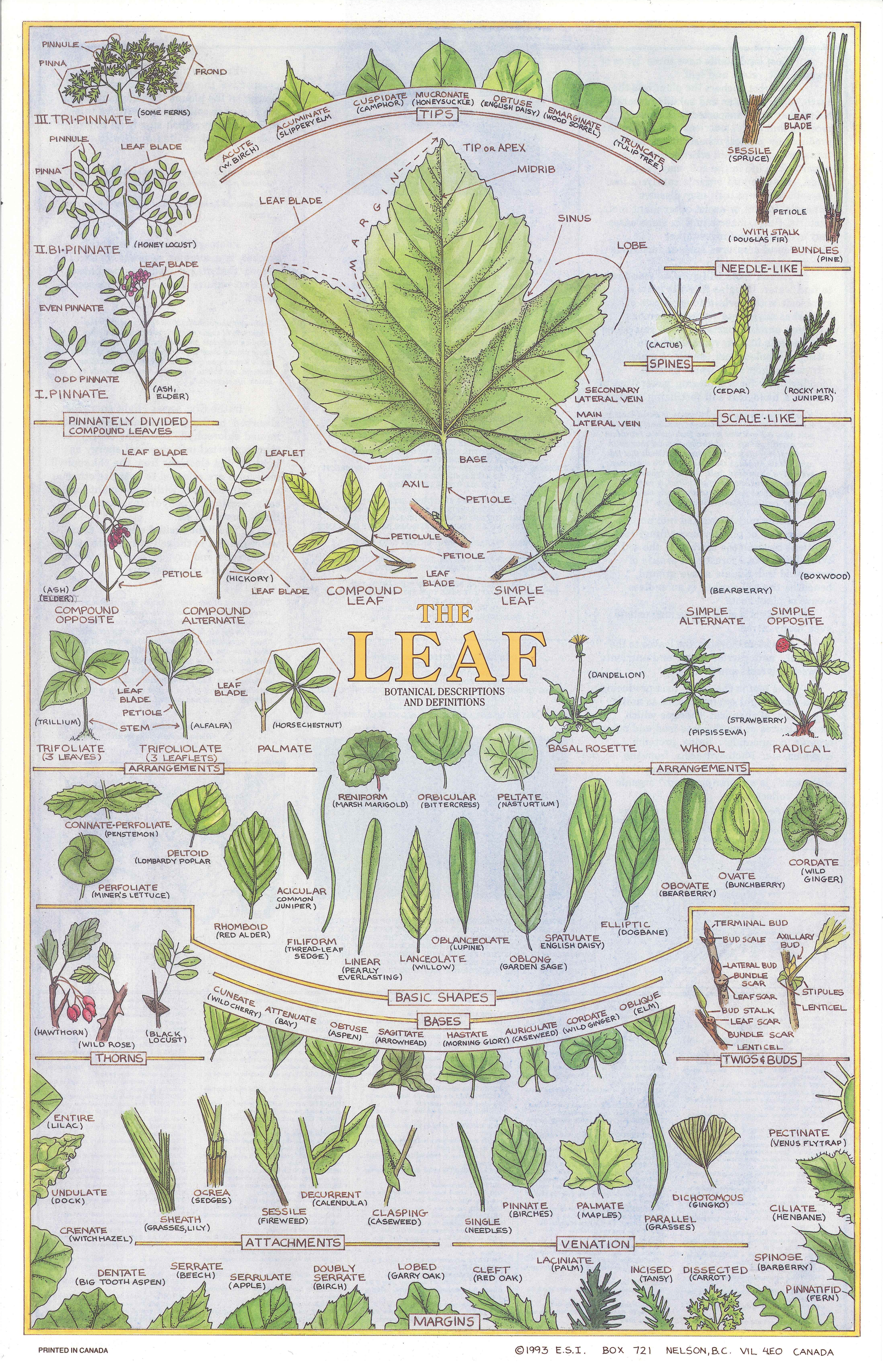


1993 The Leaf and Grasses
A set of two double-sided, illustrated botanical reference posters.
The Leaf and Grasses are a set of two double-sided posters. The colour sides accurately illustrate the botanical descriptions and definitions of the shapes, parts and identifying features of plants. At the time of production we knew of no equivalent reference, and most popular field identification handbooks had verbal descriptions and minimal black and white drawings or very small coloured ones. Each of these two posters make possible accurate identification based on only taxonomic descriptions. Each poster is small enough to take on field trips. The text and graphs on the second sides include a glossary of botanical terms, an explanation of the process of photosynthesis, the multi-species ecology of natural prairie grasslands, and define the foundational importance of green plants to all life on Earth.
Of enduring, general interest, and with broad application that does not go out of date, some of the original press run of Leaf and Grasses continues to be available for distribution.
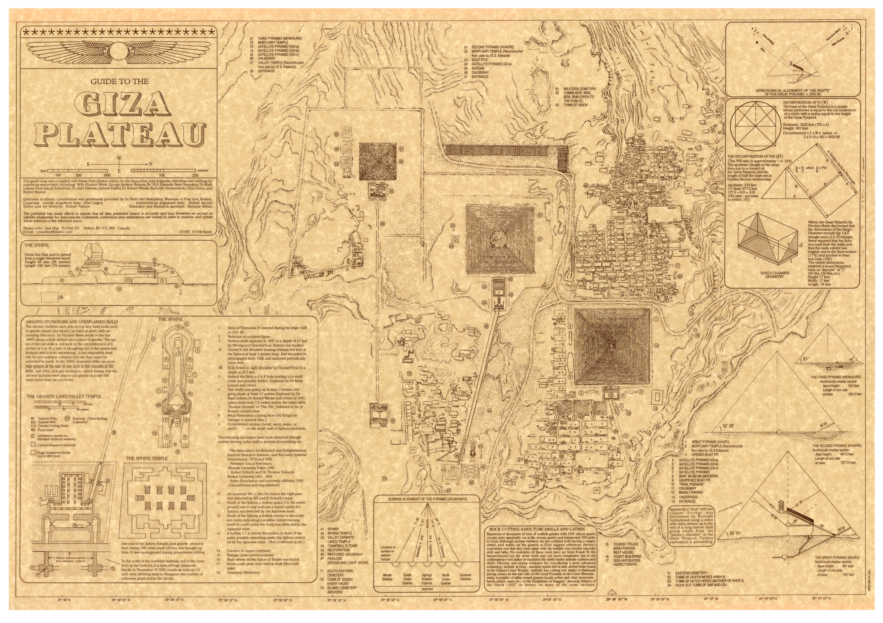
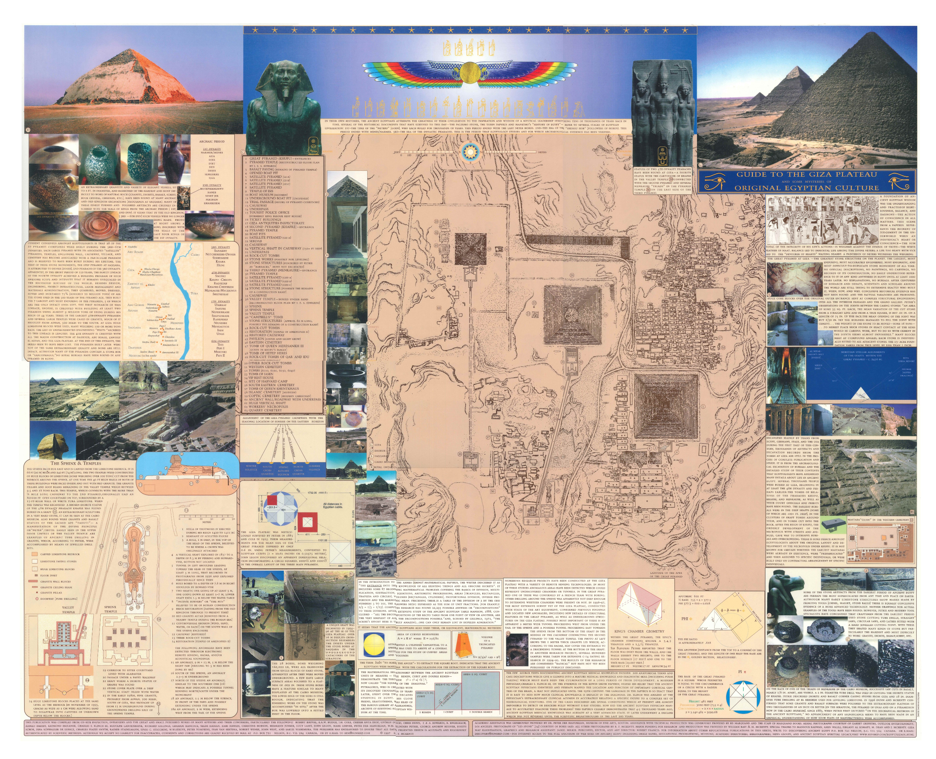
1997 A Guide to the Giza Plateau and Some Mysteries of Original Egyptian Culture
The first edition of The Guide to the Giza Plateau was the first publicly available to-scale plan map of the Giza Plateau showing all of the excavated sites around the great pyramids.
The timeless interest in Ancient Egypt led to the publication of the expanded, full colour second edition: A Guide to the Giza Plateau and Some Mysteries of Original Egyptian Culture.
Using maps and material contributed by the Boston Museum of Fine Arts; photocopies of maps and diagrams retrieved from rare, first editions held in several reference libraries; photos and videos taken by one of the founders of The Knowers Ark from his travels in Egypt; and in phone consultation with the Minister of Antiquities in Giza, a complete contour map of the Giza Plateau was compiled for the first time, showing all of the known excavated discoveries to date—pyramids, temples, tombs, mastabas—on the Giza Plateau. Also included, with the assistance of some of the leading researchers and scientists specializing in the study, are some of the mysterious and technical anomalies of the area.
Although the poster is now out of print, the accompanying website and study guide, Giza on Line, has been continuously accessed by thousands for over 20 years.
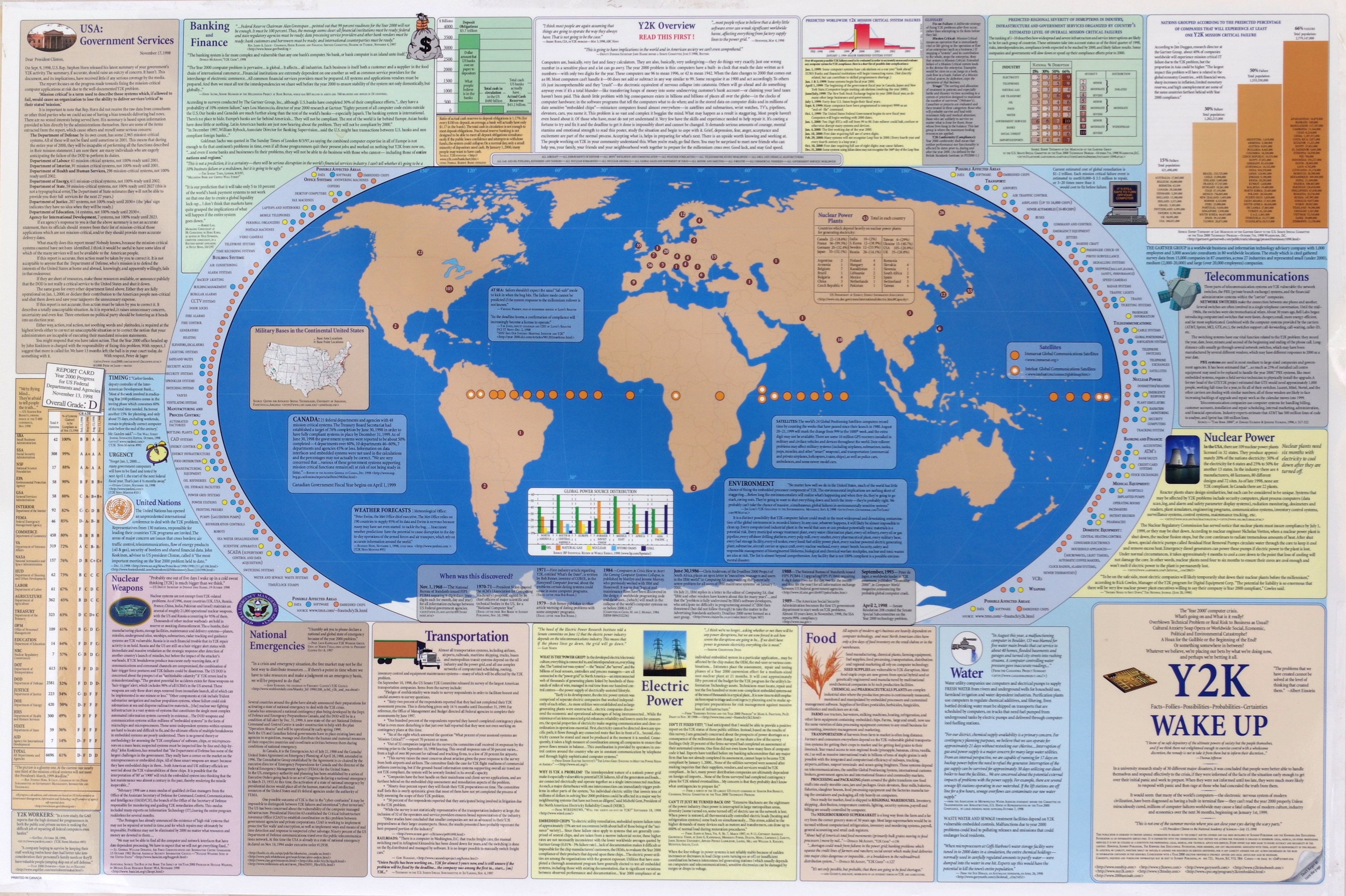
1998 Y2K Wake Up
A collation of publicly available data available as of December 1998 on the challenges of the year 2000 crossover and the extent and consequences of the world's dependency on electricity, telecommunications and computer systems.
1998 Creative Culture and the Community Ark
The second side of the Y2K poster, this is a world satellite map and resource inventory of the aspects and fundamental principles of sustainable, harmonious culture and technology. Presents references to books, websites and individual writings covering human purpose, governance, sustainable practices, home and family, and education and the arts.
12,000 posters were distributed online and on the ground by four volunteer teams travelling throughout western Canada and the United States.
2003 and 2004 The Middle East
An overview of history, issues and current conditions. An expanded and updated second edition was published in March, 2004.
This double-sided wall chart is an apolitical, unbiased and comprehensive look at the history and current conditions of the Middle East from Biblical times to the outbreak of the war in Iraq. One side of the chart shows the geographic, economic, social and human conditions of 25 countries of the Middle East. The second side, through a series of maps, illustrates the Middle East in Biblical times, and summarizes the recent political history leading to the formation of the modern nation states, the circumstances within Israel, the impact of oil production in the region and a detailed map of Iraq and Baghdad.
In two press runs, close to 20,000 Middle East wall charts have been distributed to students and individuals; government and non-government organizations; and used as curriculum material in schools, colleges and Middle East study centres throughout the world.
2005 The Bio IDs
The Bio IDs are a set of twelve, single page botanical references to bioregional and indigenous plants, designed to be used as handy field guides, or as small garden signs placed next to the living plant. Illustrated with detailed photos for quick and simple identification, each ID presents concise and succinct information about a specific plant, including: common and scientific name; classification from Kingdom to Species; the plant’s niche in the ecosystem; which native animals use it for forage; human uses such as food or medicine; additional text to assist with accurate identification; and special notes about the plant’s historical significance to the bioregion.
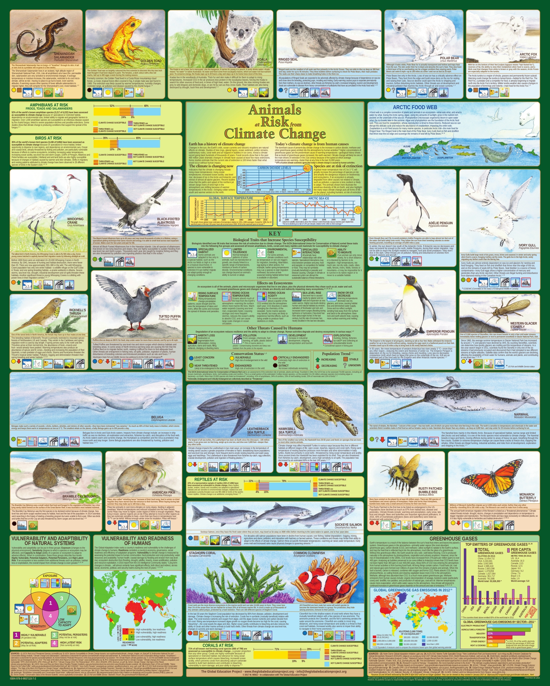
2017 Animals at Risk from Climate Change
The fundamental causes, effects and risks of climate change to ecosystems, animals and humans.
Published in consultation with the Global Education Project, Animals at Risk from Climate Change is an illustrated wall chart, interactive website, and digital presentation, featuring 25 animals that highlight the fundamental impacts of greenhouse gases—causes, effects and risk of extinction—on all forms of life on the planet. The complex interaction of biological traits and environmental conditions that cause a species to be susceptible to climate change, the basics of the carbon cycle, and the impact of greenhouse gases are made simple and understandable through illustrations, symbols and brief explanatory text.
About 50% of the initial press run of 7,000 has been distributed to universities and schools, educators, students, and environmental activists. These resources continue to be a timely and relevant educational aid.
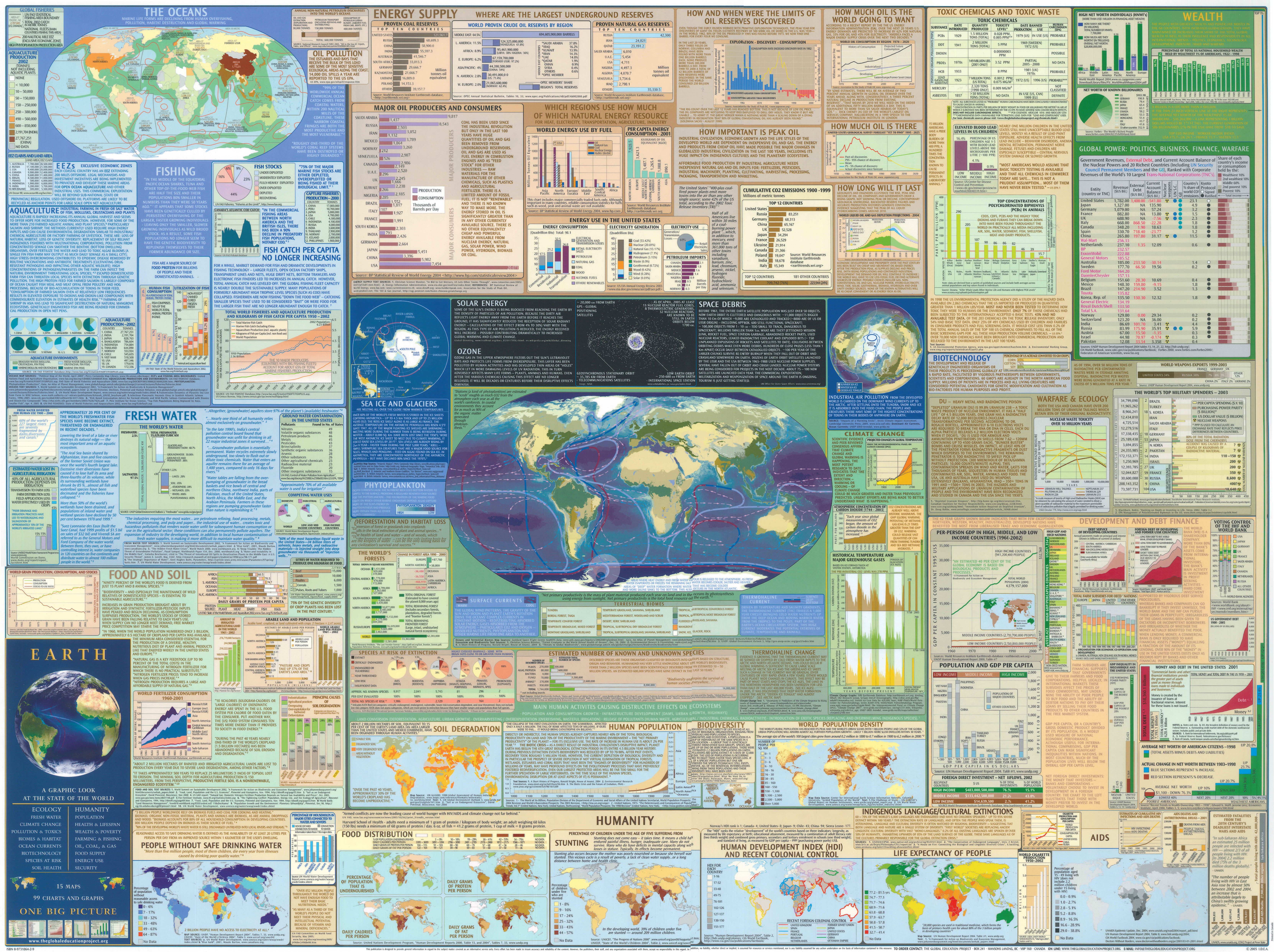
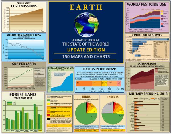
2005 and 2020 Earth: A Graphic Look at the State of the World
Presents essential data and commentaries on the condition of the world's environment—both natural and human.
First published in 2005 and updated in 2020, Earth: A Graphic Look at the State of the World, is an overview of the state of the planet: ecosystems, human and non-human species. Earth, rigorously researched and sourced, is a succinct and comprehensive presentation of the global environmental and human issues of the day: oceans and fisheries; food and soil; fresh water; toxics and pollution; energy supply and climate change; human health and welfare; global economics and militarization; wealth and economic disparity.
12,000 of the 2005 printed poster have been distributed to teachers, professors, environmental study centres, NGOs and activists. The Global Education Project interactive website has been used by almost a million people. The 2020 updated edition of Earth, which includes expanded sections on climate change, plastics and fossil fuels, is now posted freely on the website and available to download as a digital presentation.